History and Geography
Section Summary
The Negev and nearby areas of the Middle East are considered the “cradle of civilization.” Earliest settlements and agricultural domestication of a wide range of fruit, crops and animals all had their origin in this area, facilitated by the reliable and moderate nature of the Mediterranean climate: wet, cool winters and warm, dry summers. This climate system favors highly resilient vegetation, composed of fast-growing, nutritious annual plants and a variety of drought-tolerant trees and shrubs, and including a high proportion of nutritious, edible plant species. While early societies exploited these advantages for establishing advanced agriculture, first settlements and advanced civilizations, rapid population growth and resource consumption induced dramatic degradation of local vegetation and soils. The native, now-domesticated, crop and fruit variants nevertheless supported booming civilizations in the area, in spite of a strongly varying climate and the onset of desertification. The Wadi Attir area was at a crossroads between major population centers, and multiple archeological finds from the Stone Age to the Byzantine period at the project site document the intensive, long-lasting agricultural exploitation of the area. Project Wadi Attir holds evidence of the agricultural technologies of the Byzantine period, as well as the ancient tool-making skills of the Neolithic period within a very small area, pointing to the high value of this area to its human inhabitants, lost only due to wars and mismanagement during the turmoil of the Middle Ages.
…
Regional Map
Israel and Palestine form the geographical center linking three continents which has given rise to mankind and human civilization. The area is the only through-road from the Nile Valley and Central Africa to Asia Minor, and from there, to the vastness of Asia and Europe. Early human ancestors appear to have already passed through the area millions of years ago and traces of human activity spanning hundreds of thousands of years can be found there. The Hura area is strategically located, whereby roads from the rich coastlands cut inland towards the ancient settlement of Beer Sheba, and from there to Arad or the fertile highlands of Judea, Hebron or Jerusalem, bypassing the hostile Negev Desert.

Schematic annotation of the Project Wadi Attir area
The Northern Negev was the center of the Natufian culture about 13,000 to 8,000 years ago and has been densely populated and intensively exploited for hunting, grazing and field crops. Subsequently, for the last 8,000 years, the area has been dominated by the two thriving historical townships of Arad and Beer Sheba. Hura and the Project Wadi Attir area are located strategically between these two, and nearby the younger thriving settlements of the Judean Mountains (Fig. 1).
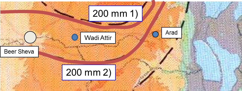
Fig. 1: Schematic annotation of the Project Wadi Attir area (green rectangle), indicating major historical settlements and possible roads (red), major dry river systems (blue), and the 200 mm isohyet (zone of equal average precipitation of 200 mm per year) in green. Clearly, the Wadi Attir site has been strategically placed at the intersection of major roads, and near major river systems entering the fertile loess plains, in a precipitation zone sufficient for grazing, field crops and dryland agroforestry.
Middle Eastern Climate History
The climate in the Northern Negev has for the last 10,000 years been rather constant: a semi-arid to arid Mediterranean type with cool, wet winters and hot, dry summers. Rainfall averages from 150 – 300 mm per year. Though some fluctuations appear to have occurred, with interchanging wetter and drier periods (Fig. 2), the steep precipitation gradient in the West-East and North-South directions in the area of Project Wadi Attir means that the critical 200 mm per year isohyet probably never shifted by more than 10 – 20 km north or south (Fig. 3), leaving the Judean Mountain foothills and the Wadi Attir area always within precipitation ranges acceptable for human subsistence, and allowing for simple field crops, grazing, and the cultivation of dryland tree crops. Nevertheless, those fluctuations in precipitation may have provided the necessary incentives for developing more resilient and sustainable dryland agroforestry systems, reliant on terraces, floodwater harvesting, simple irrigation systems and adequate dryland tree and crop species.

Indicators for Middle Eastern Climate History
Fig. 2: Indicators for Middle Eastern climate history as deduced from four independent parameters (Issar and Zohar 2007, Climate Change: Environment and History in the Near East). The blue lines indicate present-day levels (except for the Dead Sea level, where a last century level of -380 m was applied). While clear, dry, and wet periods are evident, no disastrous climate changes seem to have occurred, allowing settlement of the Northern Negev throughout this period. During the Neolithicum, when first civilizations were established in the area, climate was apparently somewhat more humid, favoring the rapid expansion of early settlements and civilizations.
Current Climate at Wadi Attir
Fig. 3: The current climate at Project Wadi Attir is located at the interface between arid and semi-arid conditions, with around 200 mm of precipitation annually. Precipitation can vary significantly, indicated by the fact that averages produced from 1) 1948 – 1987 and 2) 1961 – 1990 give a significant difference as to the location of the annual 200 mm isohyet. While this is of little significance to the Beer Sheba and Wadi Attir locations, for the city of Arad, those fluctuations have led to several periods of abandonment, apparently due to excessive drought.
Regional History
Palestine-Israel-Mesopotamia saw the onset of Eurasian civilization more than 10,000 years ago, with the emergence of the Natufian culture. Vegetation in the area is centered on Mediterranean forests and woodlands, or maquis, and open savannas and grasslands, featuring more than a hundred species of edible cereals, fruits, nuts and other plant parts. Restored woodland areas in the Northern Negev feature Pistacia, carob, oaks, Ziziphus and other dryland fruit tree species, together with many edible weeds, seeds, cereals and mushrooms (Fig. 4), making the area a veritable “Garden of Eden” for man and animals alike, even under the semiarid or arid climates typical to the area. A central objective of Project Wadi Attir is restoring patches of such diverse, productive dryland vegetation for the purposes of demonstration and biodiversity conservation. Civilization was initiated de facto by the Natufian Culture that ruled the Middle East between 13,000 and 8,000 years ago. The Natufian culture is considered to be responsible for establishing the first towns and settlements, and for the domestication of dogs, grains and livestock. Wheat, barley, cattle, goats and grapes were all domesticated in the area between 8,000 and 10,000 years ago. Possibly the most decisive pillar of Mediterranean cultures, the olive tree, was domesticated in the Middle East over 6,000 years ago, together with many additional fruit and vegetable species.

Semi-arid Woodland Vegetation (Maquis)
Fig. 4: Arid to semi-arid natural vegetation in the area is often highly productive, diverse Mediterranean woodland (or maquis), with oak, Pistacia, carob, Ziziphus and many edible herbs and grains, as evident in a few properly managed reserves and private farms. It is the aim of Project Wadi Attir to restore such fertile and diverse arid vegetation in parts of the restored project locations.
Archeological Sites at Wadi Attir
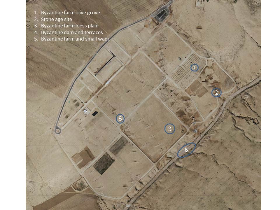
The Project Wadi Attir site bears witness to intensive agricultural use in the distant and not-so-distant past, with abundant remains from both the Neolithic and the Byzantine period (Fig. 5).
Archeological Sites at Project Wadi Attir
Fig. 5: Project Wadi Attir, like all of the surrounding Negev, features a wide range of archeological relics, bearing witness to thousands of years of human settlement and widespread agricultural exploitation of the area. The site reveals ruins of at least four farms from the Byzantine period including numerous archeological relics, and a full-scale Byzantine riverine agroforestry system, including a dam and large-scale terrace system established along the riverbanks. In addition, a Stone Age archeological site including numerous artifacts of Stone Age activities is located at a major side valley.
Stone Age Artefacts
The evidence for human activity during the Stone Age at the confluence of Wadi Attir and its major side valley are the numerous flint artifacts (Fig. 6) found there. Apparently, flint was a valuable resource available at the transition from the Judean Mountains to the Negev’s loess plains, which attracted early inhabitants to the area for collection and tool preparation.

Stone Age Tool #1

Stone Age Tool #2
Fig. 6: Pottery remains and Stone Age tools are abundant along the slopes of the valley
Finds from the Byzantine Period
There are multiple indications of intensive agricultural use of the Wadi Attir area during the Byzantine period. An impressive mosaic floor from the same period was recently detected near Hura, indicative of advanced settlement activities and dense agricultural exploitation of the area.
At least four former farmhouses, and possibly a whole settlement, have been found along the rocky slopes of the site (Fig. 7 and 8), apparently exploiting the wadi by maintaining an advanced system of irrigated agroforestry terraces along the riverbed (Fig. 9 and 10), while also farming field crops and raising livestock. This successful combination has been maintained in the Middle East for thousands of years and guarantees quality food and high resilience during both wetter and drier periods.

Most Massive Ruins
Fig. 7: The ruins of the most massive building are found near the new olive grove, in a strategic position overlooking the Attir valley, and the road and river crossing from Arad. An abundant collection of shaped rock ruins along this slope may hint at the presence of a full settlement on this site.

Well-Preserved Farmhouse
Fig. 8: An additional well-preserved farmhouse is located near the river and the agroforestry dam, with at least two rooms clearly recognizable.
Large-scale Riverside Agroforestry Systems
The findings in the wadi, along both sides of the riverbed, along with partial dams and other fortifications still visible along the riverbank (Fig. 9), indicate that the river was intensely exploited for sophisticated agroforestry systems. Based on the numbers of large, shaped rocks found along and in the riverbed, it can be assumed that the river was bordered on both sides by at least two layers of agroforestry terraces (Fig. 10), built of massive rock and protected from erosion by large dams. In combination with temporary waterholes and wells in the riverbed, these terraces would have permitted intensive agriculture along the river, bolstered by livestock grazing on the loess plains. This combination of highly sustainable and resilient farming systems explain the high density of farmhouses observed at the site (see Fig. 5).

Ancient Rock Dam

Agricultural Terraces
Fig. 9: An ancient rock dam apparently built to stabilize agricultural terraces along the river. A rock barrage across the river was likely exploited to create a temporary reservoir during winter, and used for irrigation (left). The large rocks embedded in the riverbank (right) are remains of large terrace structures that were likely used for intensive, seasonally-irrigated agriculture or agroforestry, as modelled in Fig. 10.

Riverbank Terrace Model
Fig 10: The riverbanks reveal a clear indication as to the sophisticated use of this dry river system for agricultural purposes during the Byzantine period. A natural rock barrage (right side in the wadi) was likely exploited for creating temporary water pools used for irrigation. Stone-enforced terraces along both riverbanks (remnants are visible along the river bed) were likely used for intensive irrigated agroforestry plantations for growing traditional Mediterranean dryland trees such as figs, grapes, almonds, olives, and pomegranates, as well as field crops and vegetables.